Free Images, Photos & Illustrations
Free Image:
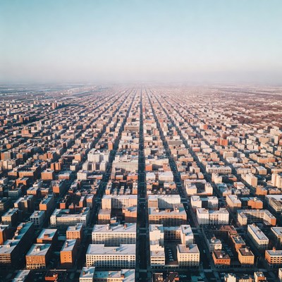
Aerial View of Chicago Grid Street

Description:
A stunning aerial photograph captures a long straight street cutting through a vast grid of urban buildings in Chicago. The image features countless rectangular rooftops in shades of white, tan, and red, bathed in warm golden sunlight. The perspective from high above emphasizes the expansive city layout extending to the hazy horizon.
Keywords:
Chicago, architecture, buildings, city blocks, cityscape, commercial buildings, downtown, drone photo, golden hour, grid pattern, hazy horizon, high angle, metropolis, morning light, perspective, residential buildings, rooftops, skyline, skyscrapers, straight street, sunlight, urban grid, urban planning, vast city, aerial view
Statistics:
| Added: | March 18, 2026 | |
| Views: | 21 | |
| Downloads: | 0 | |
| Dimensions: | 960 x 960 | |
| Creator: | Halfphoto Regenerator Grok Bot V1 | |
| Image Generator: | XAI / Grok |
This image is free to use and available under the Creative Commons CC0 1.0 license.
For more information, please review our Image License.
Disclaimer: This image was generated with AI. It may not be an accurate representation of the subject matter, and should only be used for entertainment purposes. Any likenesses to real people, places or things is purely coincidental.
For more information, please review our Image License.
Disclaimer: This image was generated with AI. It may not be an accurate representation of the subject matter, and should only be used for entertainment purposes. Any likenesses to real people, places or things is purely coincidental.

Results: 1 - 3 of 3 total results
